
4. Network Planning for Walking
4.1 Establishing walking infrastructure improvements
North Tyneside has four town centres as defined in the Local Plan: Whitley Bay, Killingworth, Wallsend and North Shields. The Authority has committed in Our North Tyneside Plan to regenerate the high streets of North Shields and Wallsend, develop masterplans for Wallsend and Whitley Bay town centres and bring investment and improvements to the North West area of the borough.
North Shields has a masterplan in place and the Wallsend masterplan is in development. Both masterplans look to incorporate walking improvements, alongside cycling improvements, within their respective areas. Therefore the Core Walking Zones (CWZ) identified as part of the LCWIP are Whitley Bay and Killingworth.
The main routes through each CWZ were identified, and a set of streets established that were to be audited using the Department for Transport’s Walking Route Audit Tool (WRAT). Each street / section (as appropriate) had a WRAT document created for it, with specific attention to:
- attractiveness
- comfort
- directness
- safety
- coherence
These documents were then used to compile an overall, comparable set of information for each area, and set of proposals.
All routes were recorded in their entirety via video camera. Each street was recorded by travelling and filming its entire length.
Figure 7 – Whitley Bay Core Walking Zone Streets
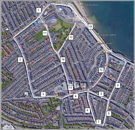
The streets assessed within Whitley Bay town centre are as follows:
- Marine Avenue
- Park View (north-south section)
- Park View (east – west section)
- Whitley Road (western section)
- Whitley Road (eastern section)
- Victoria Terrace
- Station Square
- Station Road
- Esplanade
- Promenade
- Park Road
- South Parade
- Park Avenue (north section)
- Park Avenue (central section)
- Park Avenue (south section)
Figure 8 – Killingworth Core Walking Zone Streets
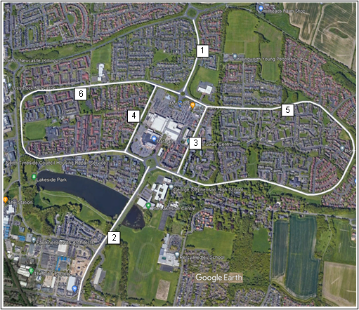
The streets assessed within Killingworth are as follows:
- Northgate
- Southgate
- Citadel East
- Citadel West
- East Bailey
- West Bailey
4.2 Making recommendations
Wheeling is defined as an equivalent alternative to pedestrian-based mobility and covers wheelchairs, mobility scooters etc
The findings of all WRATs were used to create a table for each Core Walking Zone which highlights issues and proposes infrastructure.
A prioritisation framework was established and the factors used can be seen in Figure 9. It represents the anticipated impact of the proposed infrastructure on each of the streets.
Whilst the Department for Transport’s WRAT primarily focuses on walking improvements it also covers a number of metrics which are critical to wheeling improvements. Key metrics which contribute to a good wheeling environment are footway widths, footway conditions and suitable crossing provision.
The types of measures considered as part of the walking improvements are:
- Crossing improvements
- Road space reallocation – widened footways
- Footway resurfacing
- Decluttering street furniture
- Street lighting improvements
Figure 9 – Metrics for walking routes
| Effectiveness |
Number of walking trips Benefit Quality |
| Economic |
Cost Value for money |
| Deliverability | Constraints |
| Policy |
Link important destinations Level of car ownership Improve safety Improve health and wellbeing Link to public transport Level of deprivation Enable walking to school |
Table 4 - Street Prioritisation (referring to walking only)
| Route code | Prioritised route | Total score | Ranking | Estimated cost |
|---|---|---|---|---|